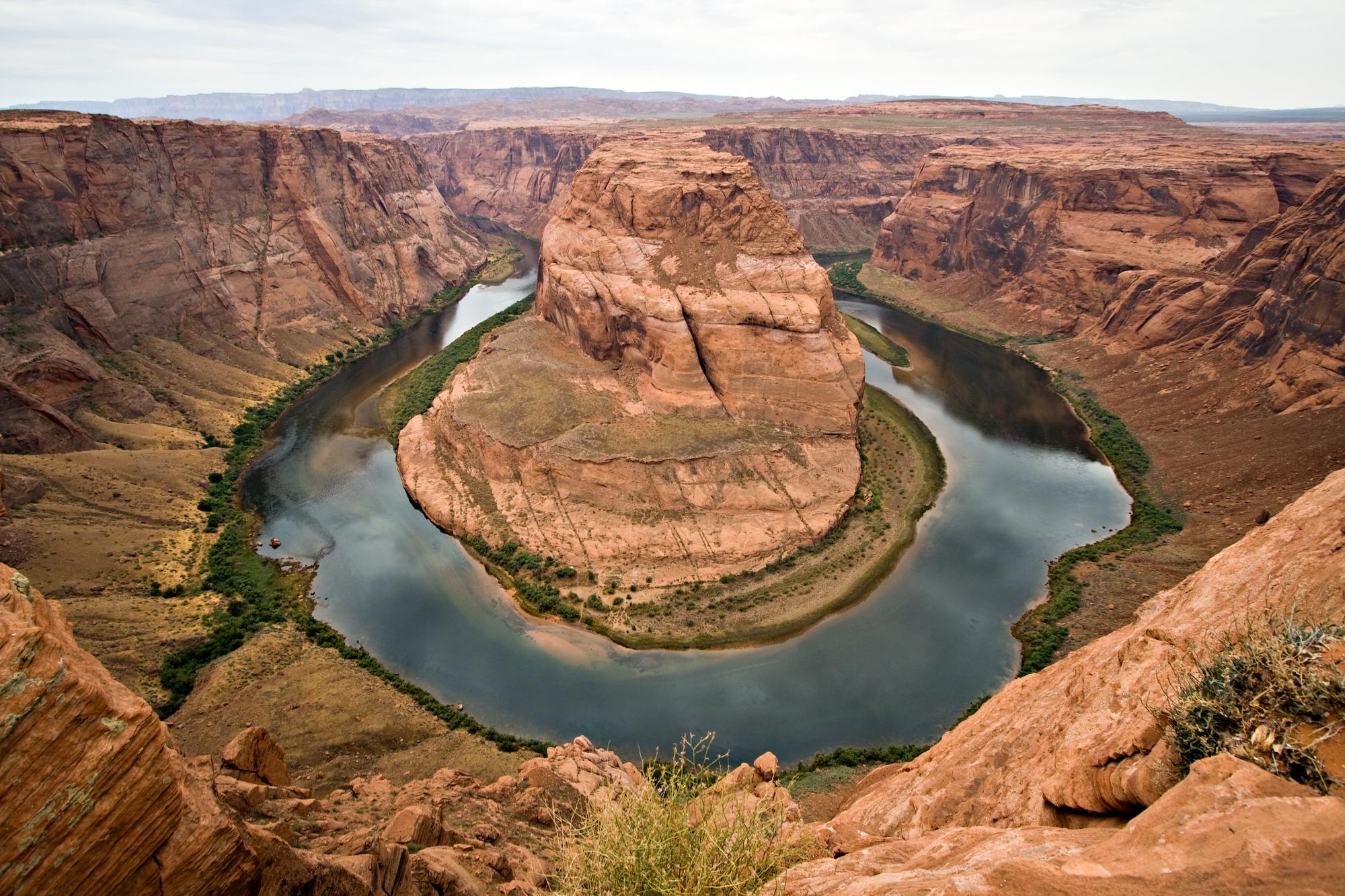
Dead Horse Point State Park offers breathtaking views of the Colorado River as it winds through deep canyons carved over millions of years. The park’s main overlook stands 2,000 feet above a dramatic gooseneck bend in the river, providing one of the most photographed vistas in the American Southwest. Visitors can explore scenic rim trails, witness stunning sunrises and sunsets, and marvel at the raw beauty of this iconic landscape where the Colorado River has shaped towering sandstone cliffs.
What Makes Deadhorse Point Colorado River Unique?

Dead Horse Point State Park is renowned for its spectacular views of the Colorado River and surrounding canyon country. The park’s main overlook provides a breathtaking panorama of the river 2,000 feet below, winding through deep red rock canyons. This dramatic vista showcases millions of years of erosion that have carved the iconic landscape.
Key features that make this viewpoint unique include:
- The dramatic ‘gooseneck’ bend in the Colorado River visible from the main overlook
- Expansive views stretching over 100 miles on a clear day
- Stunning red rock formations and layered canyon walls
- The juxtaposition of the winding river against the rugged desert landscape
The park’s location on a mesa surrounded by sheer cliffs provides 360-degree views of Canyonlands National Park and the greater Colorado Plateau. This allows visitors to appreciate the full scope and grandeur of the Colorado River’s impact on shaping this remarkable terrain.
What Are the Best Viewpoints to See the Colorado River?

Dead Horse Point State Park offers several outstanding viewpoints to observe the Colorado River and surrounding canyons:
- Dead Horse Point Overlook
- Main attraction with panoramic views 2,000 feet above the river
- Showcases the dramatic ‘Colorado Gooseneck’ bend
-
Ideal for sunrise and sunset photography
-
Meander Overlook
- Stunning view of the river’s horseshoe bend
-
Highlights surrounding red rock formations
-
Colorado River Overlook
- Located on the East Rim Trail
- Close-up view of the river’s S-curve
-
Demonstrates the power of erosion
-
Basin Overlook
- More secluded viewpoint off East Rim Trail
-
Expansive views of canyon country below
-
Rim Overlook
- Part of West Rim Trail
- Rival views to main Dead Horse Point Overlook
- Unique perspective on river and canyons
Each viewpoint offers a distinct perspective on the Colorado River and surrounding landscape, allowing visitors to fully appreciate the park’s natural beauty from multiple angles.
What Hiking Trails Provide the Best River Views?
Dead Horse Point State Park features several hiking trails that offer spectacular views of the Colorado River:
- East Rim Trail
- Length: 1.5-2 miles one-way
- Difficulty: Easy
- Highlights: Views of La Sal Mountains, sagebrush flats, juniper forest
-
Colorado River Overlook spur trail
-
West Rim Trail
- Length: 2.5-3.5 miles one-way
- Difficulty: Moderate
-
Highlights: Rim views rivaling main overlook, unique geology features
-
Dead Horse Point Overlook Trail
- Length: 200 feet one-way
- Difficulty: Very easy, ADA accessible
-
Highlights: Iconic view of Colorado River gooseneck
-
Visitor Center Nature Trail
- Length: 1/8 mile one-way
- Difficulty: Very easy
-
Highlights: Views of basin, La Sal Mountains, desert plant exhibits
-
Desert View Trail
- Length: 0.5 miles one-way
- Difficulty: Easy
- Highlights: Canyon bottom views, Colorado River, Potash Ponds
These trails offer a range of difficulty levels and perspectives, allowing visitors to tailor their hiking experience while enjoying stunning views of the Colorado River and surrounding landscape.
When Is the Best Time to Photograph the Colorado River?
The best times to photograph the Colorado River from Dead Horse Point are:
- Sunrise
- Golden light illuminates canyon walls
- Potential for dramatic cloud formations
-
Cooler temperatures for comfortable shooting
-
Sunset
- Warm light creates rich colors on rock formations
- Long shadows add depth to landscape
-
Potential for spectacular afterglow
-
Golden Hour (1 hour after sunrise or before sunset)
- Soft, warm light enhances colors and textures
-
Reduced contrast for balanced exposures
-
Blue Hour (twilight before sunrise or after sunset)
- Ethereal blue light creates moody atmosphere
-
Potential for capturing stars or moon with landscape
-
Storm Clearing
- Dramatic skies and lighting conditions
- Potential for rainbows or lightning strikes
For optimal results:
– Use a tripod for stability in low light
– Experiment with long exposures for smooth water effects
– Utilize graduated neutral density filters to balance bright skies with darker foregrounds
– Consider bracketing exposures for high dynamic range scenes
Photographers should arrive early to scout compositions and set up equipment before the best light arrives.
What Facilities Are Available for Visitors?
Dead Horse Point State Park offers various facilities to enhance visitor experiences:
- Visitor Center
- Interpretive exhibits
- Gift shop
- Information desk
-
Restrooms
-
Campgrounds
- Kayenta Campground: 21 sites
- Wingate Campground: 31 sites, including yurts
-
Moenkopi Yurts: 4 yurts available
-
Picnic Areas
-
Shaded tables near visitor center and overlooks
-
Overlooks and Viewpoints
-
Multiple paved and accessible viewing areas
-
Hiking Trails
-
Over 8 miles of developed trails
-
Bike Trails
-
Intrepid Trail System for mountain biking
-
Restrooms
-
Located at visitor center, campgrounds, and main overlook
-
Water Stations
-
Available at visitor center and campgrounds
-
Parking
- Ample parking at visitor center and main overlook
-
Limited parking at trailheads
-
Accessibility
- ADA accessible trails and facilities available
Visitors should note that there are no fuel or grocery services within the park. The nearest amenities are located in Moab, approximately 32 miles away.
How Has the Colorado River Shaped the Landscape?
The Colorado River has played a crucial role in shaping the dramatic landscape visible from Dead Horse Point:
- Erosion
- Carved deep canyons over millions of years
-
Created iconic features like goosenecks and mesas
-
Sediment Deposition
- Layered rock formations visible in canyon walls
-
Each layer represents different geological eras
-
Uplift
- Colorado Plateau uplift exposed ancient rock layers
-
River continued to cut through rising landscape
-
Climate Change
- Changing river flow over time influenced erosion patterns
-
Contributed to unique desert ecosystem
-
Rock Type Influence
- Varying hardness of rock layers created step-like formations
- Softer layers eroded faster, leaving harder cap rocks
The result is a stunning landscape that showcases:
– Deep canyons up to 2,000 feet deep
– Winding river meanders and oxbows
– Towering mesas and buttes
– Colorful rock layers revealing millions of years of geological history
This ongoing process continues to shape the landscape, with the Colorado River acting as the primary architect of this remarkable scenery.
What Wildlife Can Be Observed Near the Colorado River?
Despite the harsh desert environment, the area around Dead Horse Point and the Colorado River supports diverse wildlife:
- Mammals
- Desert bighorn sheep
- Mule deer
- Coyotes
- Desert cottontails
-
Rock squirrels
-
Birds
- Golden eagles
- Peregrine falcons
- Canyon wrens
- Ravens
-
Turkey vultures
-
Reptiles
- Western whiptail lizards
- Plateau striped whiptails
- Great Basin rattlesnakes
-
Desert spiny lizards
-
Amphibians (in ephemeral pools)
- Red-spotted toads
-
Canyon tree frogs
-
Fish (in Colorado River)
- Colorado pikeminnow
- Razorback sucker
- Humpback chub
- Bonytail chub
Visitors may observe wildlife:
– Along hiking trails, especially during cooler morning and evening hours
– Near water sources, including ephemeral pools after rain
– Soaring above canyons (birds of prey)
– In vegetated areas near the rim
Remember to maintain a safe distance from all wildlife and never feed animals. Binoculars or a spotting scope can enhance wildlife viewing opportunities while minimizing disturbance.
How Does the Colorado River Impact the Local Ecosystem?
The Colorado River plays a vital role in shaping the ecosystem around Dead Horse Point:
- Water Source
- Provides critical water in arid environment
-
Supports riparian habitats along banks
-
Erosion and Deposition
- Creates diverse habitats through landscape shaping
-
Deposits nutrients in floodplains
-
Microclimate Creation
- River corridor has higher humidity
-
Moderates temperature extremes
-
Biodiversity Support
- Attracts diverse wildlife for water and food
-
Enables unique plant communities
-
Seed Dispersal
- Transports seeds along river corridor
-
Facilitates genetic diversity in plant populations
-
Nutrient Cycling
- Moves organic matter and nutrients through system
-
Supports food web from microorganisms to large predators
-
Geological Influence
- Exposes different rock layers, creating varied soil types
- Influences plant distribution based on soil composition
The river’s presence creates a complex ecosystem that includes:
– Riparian zones with cottonwoods and willows
– Desert shrublands with sagebrush and blackbrush
– Pinyon-juniper woodlands on higher elevations
– Unique microhabitats in seeps and springs
This river-influenced ecosystem supports a wide range of plant and animal species adapted to the challenging desert environment, making the area around Dead Horse Point a biodiversity hotspot in the Colorado Plateau region.

